By Sara Kidd, Senior Regional Planner & KC Filippino, Senior Water Resources Planner
Over the last decade, sources of renewable energy like solar and wind have become widespread throughout the mid-Atlantic region. Since the introduction of the 2020 Virginia Clean Economy Act and other federal incentive programs, utility-scale solar has quickly been on the rise, developed in Virginia’s agricultural and forested landscapes. This has caused concern for localities trying to get up to speed with an increase in permit applications for small (<5 Megawatts) and utility-scale solar (>5 Megawatts) projects. As state regulations are updated, localities are challenged with changing land use policies to ensure prime agricultural and farmland aren’t overly utilized for solar, ensuring local staff are equipped with the tools to address the permitting and planning process, and that residents are educated on developing projects. There are also environmental implications when altering land use from agriculture or forest to a solar farm installation. Virginia DEQ is developing toolkits for best management practices (BMPs) to manage stormwater on these sites. Current estimates by DEQ are that over 350,000 acres could include solar facilities in the state by 2045.
This month’s map visualizes a newly compiled inventory of existing and planned solar projects in Hampton Roads. The data was collected from a variety of resources to highlight the growth in solar in the region over the past eight years, when the first utility-scale solar project came online in the region. The data was compiled from Virginia DEQ, local governments, the Chesapeake Conservancy (a partner of the Chesapeake Bay Program who is mapping solar land use through machine learning models), and private industry interested in providing renewable energy across the Commonwealth.
View the full map in a new page.
The inventory contains those projects that are permitted (active, under construction, or planned) and those that have given DEQ a Notice of Intent (NOI) but are not yet permitted or under construction. There are also two private solar projects that generate power for a specific facility (Naval Station Norfolk and IKEA) as well as two educational facilities with small rooftop arrays that participate in Dominion Energy’s Solar Partnership Program. There were 45 projects identified in total.
Type of Solar Project | Number of Projects |
Utility-Scale (>5 MW) | 18 |
Small-Scale (<5 MW) | 0 |
Private | 2 |
Under Construction | 5 (1 small, 4 utility) |
Planned Projects | 14 (12 small, 2 utility) |
Rooftop Arrays | 2 |
Notice of Intent | 4 |
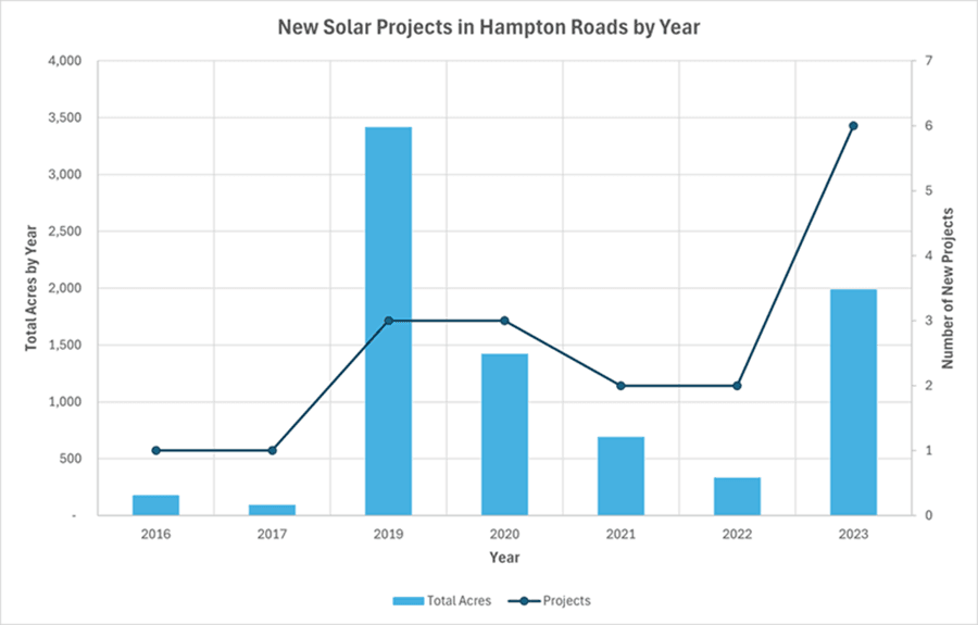
The projects on the map are symbolized by their status. Zoom into the active projects to see the approximate footprints of the projects. In most cases, the solar arrays are visible on the aerial imagery, unless the project is too new to have been captured yet. Each project is also attributed with information such as owner, Megawatt production, and the year it went into production. The chart below shows how many new projects came online each year along with the total number of acres the projects covered in that year. The 18 active solar projects in Hampton Roads cover a combined 8,152 acres.
This inventory will continue to be updated as new solar projects come online. It is challenging because the landscape is constantly changing with some projects taking years to go through the process (denials, then approvals), some that have been withdrawn, and others that have changed ownership, so only formally approved or NOI projects will be captured.